Geolocation
Lookout+ provides three different geolocation modes that determine how detected objects are positioned in space. The available mode depends on your Lookout+ version and the sensors installed on your vessel.
Geolocation Modes Overview
| Mode | Lookout+ Version | Sensor Requirements | Positioning Accuracy |
|---|---|---|---|
| Relative Bearing | Lookout+ Assist | Camera only | Bearing relative to vessel |
| Absolute Bearing | Lookout+ Augment | Camera + GPS + Compass | ~±2.0° absolute bearing |
| Range Bearing | Lookout+ Nav | Camera + Dual Antenna INS | ~±0.1° absolute bearing + range |
Mode Details
- Relative Bearing
- Absolute Bearing
- Range Bearing
Relative Bearing Mode (Lookout+ Assist)
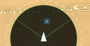
In Relative Bearing mode, objects are positioned relative to the camera's field of view without reference to absolute coordinates.
How It Works
- Camera-Centric: Objects positioned based on their location within the camera image
- Angular Reference: Uses camera field of view and orientation settings
- Fixed Distance Display: All objects appear at the same distance from vessel regardless of actual range
Calibration Requirements
- Camera Field of View (FOV): Horizontal and vertical field of view angles
- Camera Orientation: Pan, tilt, and roll angles relative to vessel
- Basic Mounting: Camera position relative to vessel center
Best Use Cases
- Recreational Navigation: Basic collision avoidance awareness
- Harbor Operations: Monitoring nearby vessel traffic
- General Surveillance: Identifying objects around the vessel
Simple setup with minimal sensor requirements. Ideal for vessels without sophisticated navigation systems.
Absolute Bearing Mode (Lookout+ Augment)
Absolute Bearing mode provides compass-referenced bearing information using GPS position and magnetic compass data.
How It Works
- Earth-Referenced: Objects positioned using true or magnetic bearing
- GPS Integration: Vessel position from GPS/GNSS receiver
- Compass Correction: Magnetic compass provides heading reference
- Fixed Range Display: Objects shown at consistent display distance
Calibration Requirements
- GPS/GNSS Position: Accurate vessel position data via NMEA 0183/2000
- Compass Calibration: Magnetic compass with deviation tables
- Camera Alignment: Precise camera orientation relative to vessel heading
- Sensor Integration: NMEA data stream configuration
Sensor Accuracy Requirements
- GPS Accuracy: Standard marine GPS (~3-5 meters typical)
- Compass Accuracy: Marine compass with ~±2.0° accuracy after calibration
- Data Rate: Minimum 1Hz position and heading updates
Best Use Cases
- Commercial Navigation: Enhanced situational awareness with chart integration
- Traffic Management: Monitoring vessel movements with absolute references
- Regulatory Compliance: Meeting requirements for bearing-based reporting
Enables chart overlay and integration with electronic navigation systems while maintaining reasonable sensor requirements.
Range Bearing Mode (Lookout+ Nav)
Range Bearing mode provides both precise bearing and estimated range using advanced inertial navigation systems.
How It Works
- Monocular Ranging: Calculates distance using single-camera geometry
- Ray Casting: Projects rays from bounding box center to water plane intersection
- INS Integration: Uses precise attitude and position from dual-antenna INS
- Real-World Coordinates: Converts detections to latitude/longitude positions
Calibration Requirements
- INS Installation: High-accuracy dual-antenna INS system
- Camera Survey: Precise camera position relative to INS center
- Waterline Offset: Accurate height of camera above water surface
- Intrinsic Calibration: Camera lens distortion and focal length parameters
- Extrinsic Calibration: Exact camera orientation relative to vessel axes
Sensor Accuracy Requirements
- INS Position: ±0.1-1 meter accuracy depending on system
- INS Attitude: ±0.1 -> 0.01° pitch, roll, and heading accuracy
- Camera Survey: Sub-centimeter positioning accuracy required
- Waterline Measurement: Accurate height above waterline critical for range accuracy
The Monocular Ranging Process
- Object Detection: Neural network identifies object and creates bounding box
- Ray Generation: Cast ray from camera through bottom-center of bounding box
- Water Plane Intersection: Calculate where ray intersects estimated water surface
- Coordinate Transformation: Convert intersection to world coordinates (lat/lon)
- Range Calculation: Compute distance from vessel to intersection point
Error Sources and Limitations
Primary Error Sources:
- INS Attitude Errors: Small attitude errors cause large range errors, especially near horizon
- Waterline Offset Errors: Incorrect height above water directly affects range calculations
- Camera Calibration: Lens distortion and mounting misalignment compound errors
- Water Surface Assumptions: System assumes flat water plane; waves affect accuracy
Distance-Dependent Errors:
- Close Objects (<100m): Generally accurate with proper calibration
- Medium Range (100m-1km): Good accuracy for collision avoidance
- Long Range (>1km): Increasing uncertainty, especially near horizon
- Horizon Objects: Maximum error due to small angular differences
Best Use Cases
- Autonomous Navigation: Precise positioning for path planning systems
- Research Applications: Accurate marine mammal position logging
- Professional Operations: High-precision collision avoidance
- Integration with GAMA: Feeding accurate object positions to autonomy systems
Range accuracy decreases significantly for objects near the horizon. INS attitude errors have the greatest impact on range estimation accuracy.
Calibration Process
Camera Field of View Calibration
All modes require accurate camera FOV settings:
- Horizontal FOV: Camera's horizontal field of view in degrees
- Vertical FOV: Camera's vertical field of view in degrees
- Lens Distortion: Correction parameters for wide-angle lenses
Basic Orientation Calibration
Required for all modes:
- Pan Angle: Camera rotation around vertical axis
- Tilt Angle: Camera elevation angle
- Roll Angle: Camera rotation around optical axis
Advanced Positioning Calibration (Range Bearing)
Additional requirements for precise ranging:
- Camera Position: X, Y, Z coordinates relative to INS center
- Waterline Height: Vertical distance from camera to water surface
- Mounting Stability: Rigid mounting to prevent alignment changes
Integration with Navigation Systems
GAMA Integration
In Range Bearing mode, Lookout+ can provide object positions to GAMA (Greenroom Advanced Maritime Autonomy):
- Real-Time Data: Detected objects automatically sent to GAMA
- Filtering: Only objects above confidence thresholds are transmitted
- Collision Avoidance: GAMA uses positions for autonomous navigation decisions
- Chart Integration: Objects displayed on electronic charts
Other Systems
- Lookout can integrate with other navigation and automomy systems. Contact Greenroom support for specific integration options and requirements.
- Regular Calibration: Verify camera and sensor alignment periodically
- Environmental Awareness: Understand how conditions affect accuracy
- Performance Monitoring: Track accuracy and adjust settings as needed